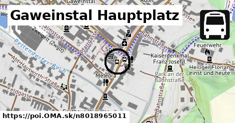
Cesta: OMA » Gaweinstal Hauptplatz

Gaweinstal Hauptplatz

Gaweinstal Hauptplatz: autobusová zastávka,
Súradnice: 48°28'36"N, 16°35'23"E

Linky na zastávke

Bus 150: Bernhardsthal Bahnhof = > Wien Floridsdorf ¤, Bus 500: Schrick Hobersdorfer Straße = > Wien Floridsdorf ¤, Bus 500: Schrick Hobersdorfer Straße = > Wolkersdorf Bahnhof ¤, Bus 500: Mistelbach Bahnhof = > Wien Floridsdorf ¤, Bus 535: Mistelbach Bahnhof = > Gänserndorf Bahnhof ¤, Bus 571: Gaweinstal Hauptplatz = > Atzelsdorf Kirche = > Schrick Josef-W.-Str. 81 (via B7) ¤, Bus 571: Gaweinstal Hauptplatz = > Pellendorf Feuerwehr = > Martinsdorf Winzerstraße = > Gaweinstal Hauptplatz ¤, Bus 571: Gaweinstal Volksschule = > Bad Pirawarth Untere Hauptstraße ¤, Bus 571: Gaweinstal Volksschule = > Martinsdorf Winzerstraße (via Schrick) ¤, Bus 571: Gaweinstal Hauptplatz = > Pellendorf Feuerwehr = > Gaweinstal Hauptplatz ¤, Bus 571: Gaweinstal Hauptplatz = > Pellendorf Feuerwehr (mit Halt in Gaweinstal Volksschule) ¤, Bus 571: Pellendorf Feuerwehr = > Martinsdorf Winzerstraße = > Gaweinstal Volksschule ¤, Bus 571: Mistelbach Alleegasse = > Martinsdorf Winzerstraße ¤, Bus 571: Höbersbrunn Obere Landstraße = > Gaweinstal Hauptplatz ¤, Bus 571: Gaweinstal Hauptplatz = > Mistelbach Bahnhof (via Mistelbach Alleegasse) ¤, Bus 571: Gaweinstal Hauptplatz = > Mistelbach Bahnhof ¤, Bus 571: Mistelbach Bahnhof = > Martinsdorf Winzerstraße ¤, Bus 571: Mistelbach Alleegasse = > Klein-Harras Hauptstraße ¤, Bus 571: Mistelbach Bahnhof = > Klein-Harras Hauptstraße ¤, Bus 571: Mistelbach Bahnhof = > Gaweinstal Hauptplatz ¤, Bus 571: Martinsdorf Winzerstraße = > Mistelbach Bahnhof ¤

Obchod

Lang ¤, Spar ¤, Monatsmarkt ¤, Stremnitzer ¤, Hairzlich ¤, Fußpflege Moser ¤, Fleischerei Wild ¤, Heilmasseur Friedrich Lötz ¤, Wein Schober ¤, Kriebaum ¤

Ubytovanie

Gasthof Klapka ¤, Zum Schwarzen Adler ¤, Gasthaus Wimmer ¤

Stravovanie

China-Restaurant Peking ¤, Andrea's Treff ¤, Andrea's Treff ¤, Pizzeria "Die Beste" ¤

šport

Hundefreilaufzone ¤, detské ihrisko ¤

Voľný čas

park ¤, Park an der Bahnstraße ¤

Služby

bankomat ¤, telefón ¤, bankomat ¤, Volksbank ¤, Polizeiinspektion Gaweinstal ¤, Gemeindeamt Gaweinstal ¤, pošta ¤

Doprava

Gaweinstal Hauptplatz ¤, Gaweinstal Gemeindeamt ¤, Gaweinstal Gemeindeamt ¤

Auto

parkovisko ¤, nabíjacia stanica ¤, parkovisko ¤, cyklopumpa ¤

Zdravotníctvo

Dr. Tatzber ¤, Apotheke "Zum Hl. Georg" ¤, Dr. Peter Tschernigg ¤

Duchovno

Johannes Nepomuk ¤, Pfarrkirche Gaweinstal ¤, Dreifaltigkeit bei der Mühlgasse ¤

Vzdelanie

skôlka ¤, základná škola ¤

Pamiatky

fontána ¤, Weißes Kreuz ¤, Kaiserdenkmal Franz Josef I. ¤, Russisches Kriegerdenkmal ¤

Bicykel

cyklopumpa ¤

Zastávky v okolí

Gaweinstal Hauptplatz ¤, Gaweinstal Hauptplatz ¤, Gaweinstal Gemeindeamt ¤, Gaweinstal Gemeindeamt ¤, Gaweinstal Wiener Straße ¤, Gaweinstal Volksschule ¤, Gaweinstal Volksschule ¤, Gaweinstal Wiener Straße ¤, Gaweinstal Martinsdorferstraße ¤, Gaweinstal Martinsdorferstraße ¤, Gaweinstal Brünner Straße ¤, Gaweinstal Brünner Straße ¤

MHD v okolí

Bus 571: Gaweinstal Hauptplatz = > Mistelbach Bahnhof (via Mistelbach Alleegasse) ¤, Bus 571: Mistelbach Bahnhof = > Klein-Harras Hauptstraße ¤, Bus 571: Gaweinstal Hauptplatz = > Pellendorf Feuerwehr = > Gaweinstal Hauptplatz ¤, Bus 150: Wien Floridsdorf = > Bernhardsthal Bahnhof ¤, Bus 500: Wolkersdorf Bahnhof = > Gaweinstal Hauptplatz ¤, Bus 500: Mistelbach Bahnhof = > Wien Floridsdorf ¤, Bus 535: Gänserndorf Bahnhof = > Mistelbach Bahnhof ¤, Bus 571: Mistelbach Alleegasse = > Klein-Harras Hauptstraße ¤, Bus 535: Gänserndorf Bahnhof = > Mistelbach Bahnhof ¤, Bus 535: Mistelbach Bahnhof = > Gänserndorf Bahnhof ¤, Bus 500: Schrick Hobersdorfer Straße = > Wolkersdorf Bahnhof ¤

Cyklotrasy v okolí

7 ¤, Weinradroute - Zweigelt ¤, 5 Laa and der Thaya - Orth and der Donau ¤

Viac o bode

Viac info: aktualizovať mapu, uprav v JOSM (pokročilé), 8018965011,
Súradnice: 48°28'36"N, 16°35'23"E
stiahni GPX, lon: 16.5899227, lat: 48.476767, og type: place,
Gaweinstal Hauptplatz

Viac o nás

Podpor projekt OMA:

QR kód na túto stránku poi.oma.sk n8018965011

Spojte sa s nami na facebooku, zdieľajte túto stránku na Facebooku, na Twittri, alebo umiestnite odkaz na svoju stránku.

Ale hlavne doplňte dáta do Openstreetmap, články do wikipédie, ...

Zdroj dát

Mapové údaje pochádzajú z www.OpenStreetMap.org, databáza je prístupná pod licenciou ODbL. OMA logoMapový podklad vytvára a aktualizuje Freemap Slovakia (www.freemap.sk), šíriteľný pod licenciou CC-BY-SA. Fotky sme čerpali z galérie portálu freemap.sk, autori fotiek sú uvedení pri jednotlivých fotkách a sú šíriteľné pod licenciou CC a z wikipédie. Výškový profil trás čerpáme z SRTM. Niečo vám chýba? Pridajte to. Sme radi, že tvoríte slobodnú wiki mapu sveta.