Obchod
Billa ¤, darčeková predajňa ¤, Anker ¤, Hugo Boss ¤, the travellers electronics company ¤, Senses of Austria ¤, Schmitt & Trunk ¤, Watch & Fashion ¤, Relay ¤, sim local ¤, Bipa ¤Stravovanie
Sky Lounge ¤, Jamie's Deli ¤, Big Daddy ¤, Kulinariat ¤, bar ¤, Jamie's Italian ¤, reštaurácia ¤, Austrian *A Lounge (Schengen) ¤, Henry ¤, Jamie Oliver's Bar ¤, Burger King ¤, Costa ¤, Wolfgang Puck Kitchen and Bar ¤, Wolfgang Puck Kitchen and Bar ¤, Brezelkönig ¤, dean&david ¤, Zapfmeisterei ¤, Wiener Würstelstand ¤, Cafe Admiral ¤, Juice factory ¤Služby
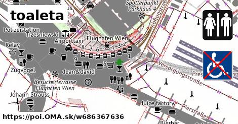
toaleta ¤, toaleta ¤, toaleta ¤, toaleta ¤, toaleta ¤, toaleta ¤, toaleta ¤, toaleta ¤, toaleta ¤, toaleta ¤, bankomat ¤, Manner ¤, bankomat ¤, toaleta ¤, bankomat ¤, Zollstelle Flughafen Wien Reisendenabfertigung ¤, toaleta ¤Doprava
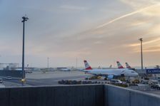
Flughafen Wien Busterminal ¤, Flughafen Wien Busterminal ¤, Flughafen Wien Busterminal ¤, Flughafen Wien Busterminal ¤, automat na lístky ¤, Flughafen Wien Busterminal ¤, automat na lístky ¤, automat na lístky ¤, Flughafen Wien ¤, Flughafen Wien Busterminal ¤, Flughafen Wien Busterminal ¤, Flughafen Wien Busterminal ¤, Flughafen Wien Busterminal ¤, Airporttaxi ¤Prístupnosť
toaleta ¤, toaleta ¤, toaleta ¤, toaleta ¤, toaleta ¤, EValidation ¤, Flughafen Wien ¤, toaleta ¤, toaleta ¤, toaleta ¤, Brezelkönig ¤, toaleta ¤, P 4 Süd ¤, P 4 Nord ¤, Bipa ¤, toaleta ¤, Besucherterrasse Flughafen Wien ¤Zastávky v okolí
Flughafen Wien Busterminal ¤, Flughafen Wien Busterminal ¤, Flughafen Wien Busterminal ¤, Flughafen Wien Busterminal ¤, Flughafen Wien Busterminal ¤, Flughafen Wien ¤, Flughafen Wien Busterminal ¤, Flughafen Wien Busterminal ¤, Flughafen Wien Busterminal ¤, Flughafen Wien Busterminal ¤, Charterbus Terminal ¤MHD v okolí
Bus 222: Flughafen Wien Busterminal = > Ebreichsdorf Bahnhof ¤, Bus 273: Neusiedl am See Hauptplatz = > Neusiedl am See Pannonia Shopping Park = > Göttlesbrunn Volksschule = > Flughafen Wien Busterminal ¤, Flixbus 901a: Bratislava, Letisko = > Flixbus 901a: Bratislava, Letisko = > Viedeň, hlavná železničná stanica (International Busterminal) ¤, Flixbus 901: Viedeň Erdberg, autobusový terminál VIB = > Bratislava, letisko ¤, Flixbus 917: Krakov, autobusová stanica MDA = > Ľubľana, autobusová stanica ¤, Flixbus N66: Hamburg ZOB = > Wien, Flughafen Schwechat ¤, Bus VAB2: Flughafen Wien = > Schwedenplatz/Morzinplatz ¤, Flixbus 901a: Viedeň, hlavná železničná stanica (International Busterminal) = > Bratislava, Letisko ¤, Flixbus 902: Budapest, Repülőtér = > Wien, Hbf. (International Busterminal) ¤, Bus 221: Flughafen Wien Busterminal = > Guntramsdorf Lokalbahn ¤, Bus 221: Flughafen Wien Busterminal = > Gramatneusiedl Bahnhof ¤