Cesta: OMA » Prottes Lerchengasse

Prottes Lerchengasse

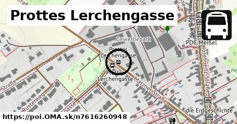
Prottes Lerchengasse: autobusová zastávka,
Gemeinde Prottes
Súradnice: 48°23'20"N, 16°44'5"E
Gemeinde Prottes

Linky na zastávke

Bus 530: Gänserndorf Bahnhof = > Wolkersdorf Wiener Straße (über Auersthal Europa-Siedlung) ¤, Bus 530: Gänserndorf Bahnhof = > Wolkersdorf Wiener Straße ¤, Bus 530: Gänserndorf Bahnhof (B) = > Wolkersdorf Wiener Straße (über Auersthal Europa-Siedlung) ¤, Bus 530: Gänserndorf Bahnhof (B) = > Wolkersdorf Wiener Straße ¤, Bus 534: Gänserndorf Bahnhof = > Zistersdorf Schloßplatz ¤, Bus 537: Gänserndorf Bahnhof = > Dürnkrut Bahnhof ¤, Bus 537: Dürnkrut Bahnhof = > Gänserndorf Bahnhof (via Matzen Schule) ¤, Bus 537: Gänserndorf Bahnhof = > Ebenthal Stillfrieder Straße ¤, Bus 537: Gänserndorf Bahnhof = > Matzen Schule ¤, Bus 537: Gänserndorf Bahnhof = > Ebenthal Stillfrieder Straße (Halt in Gänserndorf OMV) ¤

šport

detské ihrisko ¤, tenis ¤, Dorfzentrum Prottes ¤, detské ihrisko ¤

Doprava

Prottes Lerchengasse ¤

Auto

nabíjacia stanica ¤, parkovisko ¤, parkovisko ¤, parkovisko ¤

Zastávky v okolí

Prottes Lerchengasse ¤, Prottes Lerchengasse ¤, Prottes Volksschule ¤, Prottes Volksschule ¤

MHD v okolí

Bus 530: Gänserndorf Bahnhof = > Wolkersdorf Wiener Straße (über Auersthal Europa-Siedlung) ¤, Bus 537: Gänserndorf Bahnhof = > Dürnkrut Bahnhof ¤, Bus 530: Wolkersdorf Bahnhof = > Gänserndorf Bahnhof (B) ¤, Bus 530: Gänserndorf Bahnhof = > Wolkersdorf Wiener Straße ¤, Bus 530: Raggendorf Busbahnhof = > Gänserndorf Bahnhof ¤, Bus 537: Matzen Schule = > Dürnkrut Bahnhof ¤, Bus 537: Dürnkrut Bahnhof = > Gänserndorf Bahnhof (via Matzen Schule) ¤, Bus 537: Matzen Schule = > Ebenthal Stillfrieder Straße ¤, Bus 534: Gänserndorf Bahnhof = > Zistersdorf Schloßplatz ¤, Bus 537: Gänserndorf Bahnhof = > Matzen Schule ¤, Bus 537: Gänserndorf Bahnhof = > Ebenthal Stillfrieder Straße ¤

Turistika v okolí

Erdöl- und Erdgaslehrpfad Prottes ¤, wein.hügel.weg ¤

Cyklotrasy v okolí

952 ¤, OMV Erlebnisradweg ¤, Weinradroute - Traminer ¤

V kategóriách

autobusová zastávka v Gemeinde Prottes 7x

Viac o bode

Viac info: aktualizovať mapu, uprav v JOSM (pokročilé), 7616260948,
Súradnice: 48°23'20"N, 16°44'5"E
stiahni GPX, najbližšia MHD, lon: 16.7348941, lat: 48.3890918, og type: place, og locality: Gemeinde Prottes,
Prottes Lerchengasse

Viac o nás

Podpor projekt OMA:

QR kód na túto stránku poi.oma.sk n7616260948

Spojte sa s nami na facebooku, zdieľajte túto stránku na Facebooku, na Twittri, alebo umiestnite odkaz na svoju stránku.

Ale hlavne doplňte dáta do Openstreetmap, články do wikipédie, ...

Zdroj dát

Mapové údaje pochádzajú z www.OpenStreetMap.org, databáza je prístupná pod licenciou ODbL. OMA logoMapový podklad vytvára a aktualizuje Freemap Slovakia (www.freemap.sk), šíriteľný pod licenciou CC-BY-SA. Fotky sme čerpali z galérie portálu freemap.sk, autori fotiek sú uvedení pri jednotlivých fotkách a sú šíriteľné pod licenciou CC a z wikipédie. Výškový profil trás čerpáme z SRTM. Niečo vám chýba? Pridajte to. Sme radi, že tvoríte slobodnú wiki mapu sveta.